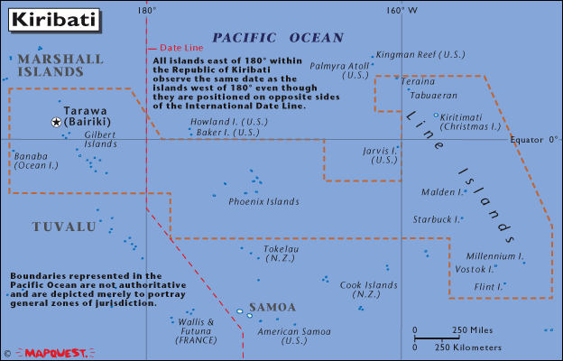
| Country (long form) |
Republic of Kiribati |
| Capital |
Tarawa |
| Total Area |
276.84 sq mi
717.00 sq km
(four times the size of Washington, DC) |
| Population |
94,149 (July 2001 est.)
|
| Estimated Population in 2050 |
235,342 |
| Languages |
English (official), I-Kiribati |
| Literacy |
N/A% total, N/A% male, N/A% female |
| Religions |
Roman Catholic 54%, Protestant (Congregational) 30%, some Seventh-Day Adventist, Baha'i, Latter-day Saints, and Church of God (1996) |
| Life Expectancy |
57.25 male, 63.22 female (2001 est.) |
| Government Type |
republic |
| Currency |
1 Australian dollar ($A) = 100 cents |
| GDP (per capita) |
$850 (2000 est.) |
| Industry |
fishing, handicrafts |
| Agriculture |
copra, taro, breadfruit, sweet potatoes, vegetables; fish |
| Arable Land |
0% |
| Natural Resources |
phosphate (production discontinued in 1979) |
|
|